In Pictures: From The Air
| Page 1 | Page 2 | Page 3 | Page 4 |
Discover Hertford Online took to the air on Sunday 14th March 2010 to take these aerial photos of the town. Click on any picture below to see a larger photo. If you're on a dial-up connection, the large image may take a minute or two to download.
 Bengeo BengeoThis photo of Bengeo shows the water tower and surrounding roads, including The Avenue, The Drive, Cowper Crescent, Peel Crescent and Woodhall Close. |
 Bluecoats BluecoatsBluecoats and Tesco dominate this photo that also shows Gascoyne Way, Stag House, Villiers Street, Ware Road and the town centre. |
 Hertford East Hertford EastWare Road runs down the middle of this picture. To the north are Villiers Street, Townshend Street Davies Street and Railway Street. To the south are Baker Street, the Madford Retail Park and Newland Gardens. |
 Queens Road & Hagsdell Road Queens Road & Hagsdell RoadA close-up of the junction of Queens Road and Hagsdell Road. The buildings in the left hand lower corner are part of Richard Hale School. |
 Gascoyne Way Gascoyne WayThe relief road runs through this picture, taken from the wets, with All Saints Church to the right and Fore Street to the left. |
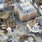
 The Wash The WashCastle Hall and The Wash are at the centre of this photo, which also shows Old Cross, St.Andrew Street and Maidenhead Street. |
 Hertford Brewery Hertford BreweryHertford Brewery dominates this photo. The Folly can also be seen at the top. |
 Foxholes Estate Foxholes EstateThis photos shows homes on the Foxholes Estate, including Reynard Way, Vixen Drive, Stoat Close, The Copse and The Briars. |
 Millmead Way Millmead WayMillmead Way and Port Vale are shown in this picture, which also shows Balfour Street, Russell Street and George Street. |
 Bengeo BengeoThis photo features part of Watermill Lane and Glebe Road, together with Revels Road. |
| Page 1 | Page 2 | Page 3 | Page 4 |