In Pictures: From The Air
| Page 1 | Page 2 | Page 3 | Page 4 |
Discover Hertford Online took to the air on Sunday 14th March 2010 to take these aerial photos of the town. Click on any picture below to see a larger photo. If you're on a dial-up connection, the large image may take a minute or two to download.
 Balls Park Balls ParkBalls Park, showing building work on a new housing development to the west of the main house. |
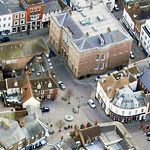
 Town Centre Town CentreThe centre of Hertford, with Fore Street running across the top left of the picture. Bircherley Green can be seen above the river with Bull Plain and Maidenhead Street to the right. |
 St. Andrew Street St. Andrew StreetSt.Andrew Street runs across the top of this picture, with Cowbridge branching off from Old Cross just below Castle Hall in the top left-hand corner. |
 Willowmead WillowmeadHertingfordbury Road and Willowmead. |
 Oak Grove & Mangrove Road Oak Grove & Mangrove RoadHomes in Mangrove Road, Mangrove Drive and Oak Grove, south of the town. |
 Pinehurst Estate Pinehurst EstateThe Pinehurst Estate, including Birdie Way and Hamels Drive. At the top of the picture is The Meads and at the bottom is part of the Foxholes Estate. |
 Hertford HertfordA view of the town looking north. Tesco is in the middle of the picture with the newly built Elder just above. London Road goes diagonally across the picture. |
 Temple Fields Temple FieldsTemple Fields from the north, showing Crouchfield and Bartlett's Mead. |
 Hertford West Hertford WestWest of the town centre, showing Gascoyne Way, Hertingfordbury Road, North Road and Sele Road. South of Riversmeet, The River Lee can be seen meandering through Castle Mead. |
 Mill Road & St.John's Street Mill Road & St.John's StreetThe L-shaped Waterfront development dominates this photo of Mill Road and St.John's Street. The picture also features Mitre Court, Hertford East station. The Hertford Basin can just be seen in the bottom right-hand corner. |
| Page 1 | Page 2 | Page 3 | Page 4 |